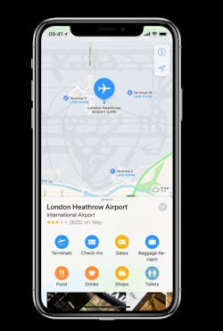
Heathrow Brings Detailed Terminal Maps to Apple Maps
Heathrow has collaborated with Apple to bring detailed terminal maps to Apple Maps, providing passengers with a powerful new tool to navigate through the airport and find what they are looking for.
Right from Apple Maps on their iPhone or iPad, passengers can plan their journey through the airport in advance of their flight, including finding nearby restaurants, places to buy last minute sun cream and gifts before take-off as well as the important points of interest such as baggage claim, customers, and restrooms.
Indoor positioning gives passengers an instant view of where they are within the terminal which helps them get to where they need to go next. And they can easily toggle between floors.
The Heathrow terminal maps in Apple Maps will be updated regularly to ensure accuracy including when new store locations and pop-ups open.
This innovative milestone is part of Heathrow’s digital transformation, ensuring passengers can plan their journey before they’ve arrived at the airport. Travellers can select restaurants on the map and gain contact information, enabling them to click straight through to book a table, reserve a product, or contact a lounge.
Stephen Glenfield, Senior Digital Manager, said: “Bringing detail terminal maps to Apple Maps marks a huge milestone in improving the digital experience at Heathrow. Improving navigation and giving passengers information about the broad and exciting retail, restaurants and services we offer as well as logistical information about where restrooms and information points are will give them the opportunity to plan every step and as a result, enjoy every moment of the journey.”
Indoor airport maps are available to all iPhone and iPad users running iOS 11 and above. Detailed airport maps are available at more than two dozen airports around the world.
