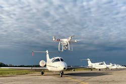
Airport Benefits of Drone Technology
Over the last five years, the use of small Unmanned Aircraft Systems (sUAS) also known as drones have exploded within the U.S. According to Time Magazine, some 3 million drones were sold worldwide in 2017 and more than 1 million drones were registered with the Federal Aviation Administration (FAA).
Several factors, including technology improvements, mass manufacturing, cost reductions, and ease of purchasing have contributed to the increase of drone purchases. Naturally, this has caused a need to evaluate the air traffic control system and determine how to integrate this new form of aviation within close proximity of manned aircraft operating at low altitudes. Great progress has been made to achieve the safe implementation of drones through the creation of the Small Unmanned Aircraft Regulations (CFR Part 107) and the FAA’s new Low Altitude Authorization and Notification Capability (LAANC).
During this same time, drones have also been a severe nuisance to airports and even caused threats aircraft. As the number of drones flying in the skies has increased, so has the number of aircraft near misses and other incidents of reckless behavior. Generally, hazardous drone operations are conducted by operators with little to no training or safety awareness.
However, the drone operating processes have changed very rapidly. With the introduction of drone specific regulations such as the 14 CFR Part 107, a safety culture was created for unmanned aircraft similar to that of manned aircraft. Part 107 lowers the potential hazard of drone activities while allowing their potential benefits to increase. In an interesting twist, the drones that once posed a hazard for airports can provide valuable services within the airport environment.
Photography
One key piece of equipment that makes drones so useful is their cameras. The vast majority of commercial drones flying today are used for some form of photography, both still and video. The quality of the photography images has increased dramatically, with the development of 4K video resolution cameras mounted from gyro-stabilized gimbals becoming increasingly common throughout the drone industry.
For airports, low-altitude aerial photography can provide a multitude of benefits beyond the obvious Public Relations opportunities. Numerous programs, such as DroneDeploy, can take the GPS information that is embedded in a series of photos and stitch them together, in order to provide a single, high-definition two or three-dimensional image of a photographed area. Traditional aerial photography aircraft have altitude restrictions of around 1000 feet above obstacles, while drones have the ability to capture images at much lower altitudes with extremely high detail, resulting in greater clarity and detail.
Engineering & Planning
A number of engineering companies have made progress using drones to create detailed pavement surveys for airport Pavement Management Programs. To that end, drone photos can also be combined with airport Geographic Information System (GIS) programs to create realistic, 3D maps of airport properties.
The low-altitude, high-definition images captured by drones can be of immense value for airport maintenance personnel seeking to document pavement discrepancies and establish repair programs, or even for airport planners who need to track the condition of particular surfaces in order to decide when a replacement is necessary. The high-definition photos can be extremely useful when providing justification for grant funding.
For example, the Saline County Regional Airport in Bryant, AR used drone photos of a sinkhole to help justify FEMA grant funding for their repair project.
Drones have also been extremely useful during airport construction projects. They can be used to collect land survey information before a project begins and help to monitor and document the progress of a project during construction phases. Drone photos can help engineers track project timelines and identify problem areas that don't meet project specifications or standards.
The Golden Triangle Regional Airport in Columbus, Miss., has used drones to document several construction projects.
Inspections
Another benefit of airports integrating drones is the ability to conduct inspections with the aircraft. Even basic photography equipment (standard on most professional drones) are excellent for providing documentation on building conditions, pavement and marking issues, and even security inspections. In some cases, millimetric-wave sensors from drones have been used to help document building shifts, or even inspect the vertical stabilizers of aircraft in a manner that maximizes effect while minimizing the potential for injury to personnel.
As seen below, the Golden Triangle Regional Airport has used drones to examine buildings, rooftops, parking lots, security fencing, windsocks, safety areas, signage and even taxiway and runway markings.
Wildlife Monitoring and Dispersal
One of the more interesting uses of drones within the airport environment concerns the issue of wildlife hazard mitigation. Since the responsibility and liability for resolving wildlife threats in the immediate vicinity of the airport rests with the airport operator, it is important to have a diverse set of wildlife control tools. Drones have been shown to be particularly effective with passive wildlife mitigation, such as scouting ponds, grasslands, or even woods that are on airport property.
However, drones can also be extremely effective in more active methods of wildlife dispersal. Remote control aircraft have been documented by the Air Force’s Bird/Wildlife Aircraft Strike Hazard teams as being very effective as a means of dispersing birds since the 1990s. However, those earlier generations of aircraft required a much higher level of skill and training than current drone modules with built-in GPS and vision systems. Both large and small birds flee the sight and noise of a drone, particularly when flown near roosting or cover areas. This can be particularly useful when reaching far-off locations that are not typically included in airport wildlife harassment programs. However, make sure to check state regulations concerning harassment of wildlife before using drones for this purpose.
Incident Command
As many experienced First-Responders know, communication and situational awareness are extremely important when an incident or accident occurs. This is particularly true in the case of aircraft crashes, with fuels, ignition sources, sharp metal and energized electrical systems posing hazards during rescue attempts.
Drones are being employed as a useful tool for Police, Fire, and even Emergency Medical Service (EMS) units. Drones can be an incredible asset during an emergency situation because they provide the means to immediately launch a low-altitude vision platform that can deliver real-time data to the Incident Command Staff. Traditional aerial views (from Police helicopters or even fixed-wing aircraft) may require anywhere from 30 minutes to few an hours to reach an incident scene, and once they arrive they may be limited in their ability to provide detailed views and data that are essential to the Incident Command Staff. When the rapid deployment capability is combined with the ease of use found in most commercial drone platforms today, the potential benefit to Airport Firefighters, Airport Police and EMS, becomes apparent very quickly.
Marketing
Airport Property Managers and Economic Developers can benefit greatly from the images drones can capture at airports. Many airports have available land and buildings that they need to advertise to prospective businesses and tenants to rent or develop. Drones make it easier than ever before to collect aerial photos and videos that can be used to promote and market available airport land and infrastructure.
For example, the Golden Triangle Regional Airport uses drone photos to market airport land that is available for commercial development.
Training
A newfound application for drone photos and video are in airport employee training materials. A drone can be used to collect images of airport signs, marking, infrastructure, and training demonstrations. These images and videos can be incorporated airport training programs such as airport driver training, airport police training, firefighter training, TSA training,
FBO training, and airline training material.
Public Outreach & Education
Over the last few years, drones have been a top Christmas gift item. As mentioned earlier, drones in the hands of untrained and uneducated individuals can be hazardous. One way airports can help to improve safety around the airport is to help provide drone education to the communities surrounding the airport. Airports have had success hosting public FAA drone educational at events. Drones can also be used as a STEM education tool to introduce students to aviation.
Cost Benefit
Lastly, it is important to consider the cost of the equipment involved. Each airport’s cost-benefit analysis may be different based upon their intended use for drones. However, there are a few examples to consider. A commercial-grade drone will typically cost between $1500--$2500, not including spare equipment such as batteries, propellers, transport cases, etc. Therefore, a medium-grade aircraft package may cost around $3500-$4000. Naturally, airports that could decide to get more sophisticated equipment (such as miniature Infrared cameras or LIDAR units) that would be significantly more expensive, closer to $15,000-$20,000.
While this may seem to be a fairly steep price point, it should be considered to the costs associated with renting a helicopter, since that would be the closest approximation to what a drone can provide. A Robinson R44 can run anywhere from $630-$800 per hour, with a Bell Jetranger costing around $1,000 for 40 minutes, not including the costs of the photographer and any other crew members.
Management & Oversight
Every airport that owns drones can manage them in different ways. Some airports may choose one department such as Operations to oversee the airport's entire drone program. While other airports may treat drones like any other type of equipment and let multiple departments manage drones separately. It’s very important that airports maintain proper management of their drone equipment, training, operations, insurance, manuals, and records. Airports that establish and maintain a drone management structure will increase their safety and reduce liability exposure.
The world of drones is changing rapidly, and as it continues to grow, more opportunities for the use of this technology are being developed. By unlocking the low-altitude airspace, drones can be used by airports to not only earn revenue but justify grant funding or even save on costs that would otherwise be spent by the airport. Large companies such as FedEx, Google, Amazon, and Uber are investing heavily in drone technology, and this will only lead to further increase in drone operations around airports. This new sector of aviation could provide the opportunity for airports to develop new revenue streams by offering areas for UAS research and development, training, maintenance, and other support facilities for the commercial industry, military, as well as for individual pilots. As the drone opportunities progress, it will be up to airport managers to establish a vision for how drones can benefit their airport.
Matt Dowell is the Deputy Director of the Golden Triangle Regional Airport in Columbus, Mississippi. He received both his Bachelor of Commercial Aviation and Masters in Aviation from Delta State University in Cleveland, Mississippi. He is an Accredited Airport Executive with over 6 years of airport management experience. Matt is also a FAA licensed Flight Instructor and Unmanned Aerial Vehicle pilot. In addition, he serves as a principle consultant for Aviation Results.
Brandon Guillot has a MS in Aeronautical Science in Aviation Management and Aviation Safety Systems from Embry-Riddle Aeronautical University and a BS in Aviation Management from Louisiana Tech University; Brandon holds both a FAA Private Pilot and Remote Private Certificate. He is an Accredited Airport Executive with 12 years experience in the Operations, Emergency Management, and Planning departments at two Part 139 airports. He also serves as an Adjunct Assistant Professor for Embry-Riddle Aeronautical University, teaching Airport Operations and UAS Management at the graduate and undergraduate levels. Brandon has over 12 years of recreational and commercial UAS experience and is the owner of Unmanned Aerial Solutions of Arkansas, training UAS pilots in addition to aerial photography services. He has assisted airports and pilots with developing plans for the safe integration of UAS at the local, regional, and national levels, and serves as a member of the FAA Safety Team.
About the Author