KAILUA-KONA, Hawaii – Hawaii Wing members and local residents alike are being encouraged to help provide the Federal Emergency Management Agency with photographic evidence of the flash-flood impact resulting from Hurricane Lane.
“FEMA is looking at the situation as a flooding event, but the information we’re getting from current monitoring systems is incomplete because those monitoring systems do not accurately reflect flash-flood data, and there are some areas where monitoring systems are not installed,” said FEMA Geospatial Information Officer Christopher Vaughan.
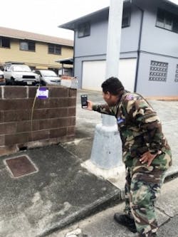
To complete the picture, CAP members were tasked with data collection in an innovative way: using their GPS-enabled smartphones and the FEMA app.
While the FEMA app itself is not new, this is the first time it’s been used in a coordinated effort to collect specific types of data — high-water marks left by receding floodwaters and water “wreck lines” left behind by flash floods.
Both high-water marks and water wreck lines are usually discernible by a line of dirt or discoloration on a structure. FEMA will analyze photos of these marks and lines and pool the results with existing data to provide impact estimates.
Qualified Hawaii Wing members will deploy in ground photography teams to procure photos using the FEMA app following specific protocols, but the app makes it easy for anyone on the islands to contribute to the data-collection mission.
All Hawaii residents 18 or over are encouraged to participate to provide FEMA with the most complete picture of the flooding. The FEMA app can be downloaded from www.fema.gov/mobile-app, the App Store for iPhone or Google Play on Android phones.
“As people return to school and work ... they can snap photos of high-water marks on homes, workplaces, trees and light poles as they encounter them and just upload them to the app,” said Col. Tim Hahn, CAP Pacific Region commander.
Hahn and two fellow members of a newly formed CAP incident management assistance team — Col. Carol Lynn, Nevada Wing commander, and her chief of staff, Lt. Col. Rich Hazeltine — arrived in Hawaii on Monday to work with members of the Hawaii Wing response team led by Lt. Col. Dana McLaughlin, incident commander.
Lane ultimately bypassed Hawaii and was downgraded to a tropical storm on Aug. 25, but from Aug. 22-26 it drenched the islands with 52.02 inches of rain, causing widespread flash floods, most heavily on the Big Island.
During Lane’s approach Hawaii Wing members spent last week providing aerial warning announcements to the public, surveying the coastline for potential hazards and preparing for post-storm taskings by FEMA and the state Emergency Management Agency.
#HurricaneLane
Civil Air Patrol, the longtime all-volunteer U.S. Air Force auxiliary, is the newest member of the Air Force’s Total Force. In this role, CAP operates a fleet of 560 aircraft, performs about 90 percent of continental U.S. inland search and rescue missions as tasked by the Air Force Rescue Coordination Center and is credited by the AFRCC with saving an average of 80 lives annually. CAP’s 60,000 members also perform homeland security, disaster relief and drug interdiction missions at the request of federal, state and local agencies. In addition, CAP plays a leading role in aerospace/STEM education, and its members serve as mentors to over 25,000 young people participating in CAP’s Cadet Programs. Visit www.GoCivilAirPatrol.com or www.CAP.news for more information.


